 Previous Article
 Next Article
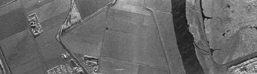
The radar images will also be used for monitoring water currents, agricultural crop mapping, and soil moisture content identification. Image credit: ESA
PARIS (BNS): A compact, high-resolution radar, designed by using radar technology from the European Space Agency�s (ESA) Envisat remote-sensing satellite, will help in mapping land-based structures.
The radar, which can be fitted on small unmanned aircraft and also on single-engine aircraft, can monitor dams, harbours, canals and buildings, leading to maps for urban planning, territory surveillance and cadastral updating, the ESA said.
�Because our system is so compact, it can be mounted on very small unmanned aircraft or on single-engine aircraft such as the Cessna 172. This makes it easy to take as many pictures of items or areas on land as necessary, at a much lower cost than traditional surveys,� said Adriano Meta, inventor of the radar and Director of MetaSensing, the company he started to provide the service.
On the designing of the instrument, Meta said, �We developed our high-resolution mapping sensor by integrating the synthetic aperture radar technology developed by ESA and the Technical University in Delft.�
The synthetic aperture radar (SAR) technology, developed by ESA for its satellites, has been used for various applications, such as providing terrain information to geologists to understand ground movements and help in mineral exploration, imaging oil spills in water to help public agencies intervene at the right time, and mapping ice hazards for navigators. SAR can take 3D pictures through clouds and darkness, which has made it possible for ESA�s Envisat and ERS satellites to track changes accurately in the polar ice sheets.
While satellites are ideal for providing information on large regions and remote locations on Earth, more frequent flights and higher resolution could in some cases be an advantage for local areas and structures.
The use of a small aircraft makes it much easier to plan the coverage and repeat measurements of an area over time to detect changes and identify potential weaknesses in geological and architectural structures. Several flights also make it possible to spot changes of objects on the ground, the ESA said.
�With this system, we can provide a cost-effective service to private companies and public institutions that need accurate mapping, millimetre deformation monitoring, change detection and vegetation classification on a frequent basis,� Meta said.
The sensor is expected to be operational by later this year.


The Indian Air Force, in its flight trials evaluation report submitted before the Defence Ministry l..
view articleAn insight into the Medium Multi-Role Combat Aircraft competition...
view articleSky enthusiasts can now spot the International Space Station (ISS) commanded by Indian-American astr..
view article