 Previous Article
 Next Article
An internet image.
BEIJING (PTI): China has formally launched full global services of its BeiDou-3 Navigation Satellite System (BDS) to rival the widely-used American GPS and provide independent navigation structure for its increasingly modernising military.
Chinese President Xi Jinping attended a ceremony on Friday (31st July) to mark the launch of full global services of the BeiDou-3 in Beijing, official media reported.
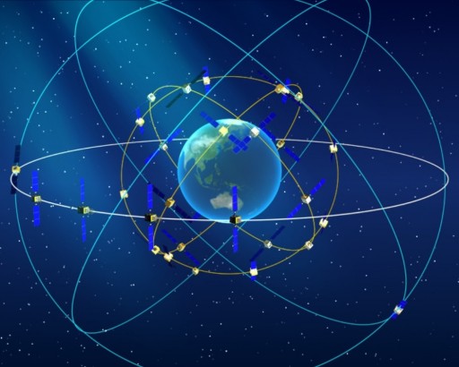
The launch marks the completion of China's domestically developed BeiDou network, one of the four global navigation networks alongside the US' GPS (Global Positioning System), Russia's GLONASS and the European Union's Galileo.
India too is building its navigational system called the Indian Regional Navigation Satellite System (IRNSS), with an operational name of NAVIC.
Some of the countries like Pakistan, closely aligned with China, are using the BDS. China is also promoting its use in the countries signed-up for its mega Belt and Road Initiative (BRI).
For the Chinese military, the BeiDou provides an independent navigation system, especially for its missile launches.
"The main advantage of having your own system is the security of access, in the sense that you are not relying on another country to provide it. The US could deny users access over certain areas, for example in times of conflict," Alexandra Stickings from the Royal United Services Institute for Defence and Security Studies said.
"It could also serve as a back-up if GPS were to go down entirely," she added.
The chief designer of the BDS, Yang Changfeng, said BeiDou offers accurate positioning, navigation and timing, as well as short messaging communication.
The services are used in various fields, including transportation, agriculture, fishing, and disaster relief.
It offers an alternative to Russia's GLONASS and the European Union's Galileo system, as well as America's GPS, Yang said.
Named after the Chinese word for the Big Dipper or Plough constellation, China's BeiDou navigation project was launched in the early 1990s.
The system then became operational within China in 2000 and in the Asia-Pacific region in 2012.
With the upgrade of its third-generation satellites, the constellation consisting of 35 satellites is ready to provide global coverage, state-run CGTN TV reported.


The Indian Air Force, in its flight trials evaluation report submitted before the Defence Ministry l..
view articleAn insight into the Medium Multi-Role Combat Aircraft competition...
view articleSky enthusiasts can now spot the International Space Station (ISS) commanded by Indian-American astr..
view article