 Previous Article
 Next Article
NEW DELHI: Indian air space management would undergo a sea change in the next few years with the implementation of a slew of measures, like satellite-based air navigation system, for seamless and cost-effective use of the skies by the civilian and military aircraft.
As part of the steps being taken by various agencies, the Indian Air Force is already in the process of reviewing the 'Restricted' and 'Dangerous' air zones in a bid to expand areas for civilian air traffic, official sources said here on Tuesday.
�We are moving ahead step by step. One after the other recommendations of a high-level technical committee is being taken up for implementation,� the sources said.
When contacted, Director General of Civil Aviation Kanu Gohain said, �As far as we are concerned, we have implemented the flexi-use of airspace. Now, the next steps in this direction are being taken by the military authorities.�
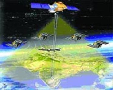
Two weeks ago, the Union Cabinet had approved the implementation of GPS-aided Geo Augmented Navigation (GAGAN) system at an estimated cost of Rs 774 crore to enable satellite coverage of the entire Indian sky, including the oceanic airspace around it.
GAGAN, being developed by the Airports Authority of India and the Indian Space Research Organisation, would make India the fourth in the world after the US, Japan and the European Union to have such a system. GAGAN would depend on 29 satellites giving GPS coverage to provide seamless navigation to aircraft using the Indian airspace.
The project, to be operationalised by May 2011, would provide straight-line fuel-efficient routes and precision approach landings, thereby reducing fuel burn substantially.
GAGAN would also improve airport and airspace access in all-weather conditions and provide precision-landing approaches to aircraft even at airports, where Instrument Landing Systems do not exist. It would enhance safety by enabling the use of three-dimensional approach to help the pilots.
ISRO would put into orbit the navigation payload of GSAT-4 satellite, the officials said, adding that orders have been placed for supply and installation of GAGAN's ground network, including hardware for eight reference stations, a Master Control Centre and the uplink stations.
The high-level technical committee, headed by former Civil Aviation Secretary Ajay Prasad, had proposed a Master Plan for next-generation futuristic Air Navigation Services, including enhanced flexibility in airspace use by civilian and military aircraft, the sources said.
It had recommended several steps to strengthen air traffic control (ATC) systems and procedures, especially at metro airports, to increase the air traffic handling capacity.
These include implementation of the Required Area Navigation (RNAV) and Required Navigation Performance (RNP) procedures at Mumbai and Delhi, the sources said.
The AAI has already begun the process of putting up ten radars to help reduce the spacing of aircraft and increase the capacity of air space. All radars are to be networked within this financial year and the ten new Radars would be operated from Delhi and Mumbai, they added. (PTI)


The Indian Air Force, in its flight trials evaluation report submitted before the Defence Ministry l..
view articleAn insight into the Medium Multi-Role Combat Aircraft competition...
view articleSky enthusiasts can now spot the International Space Station (ISS) commanded by Indian-American astr..
view article