 Previous Article
 Next Article
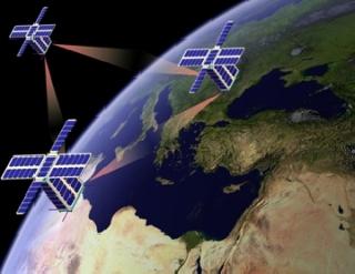
WASHINGTON (PTI): Scientists are planning to use mini-satellites that function as 'space cops' to help avoid collisions of satellites and debris in space.
Researchers at Lawrence Livermore National Laboratory, US, used a series of six images over a 60-hour period taken from a ground-based satellite to prove that it is possible to refine the orbit of another satellite in low Earth orbit.
"Eventually our satellite will be orbiting and making the same sort of observations to help prevent satellite-on-satellite and satellite-on-debris collisions in space," said Lance Simms, lead author of research.
Collisions in space of satellites and space debris have become increasingly problematic, researchers said.
To help satellite operators prevent collisions in space, the Space-Based Telescopes for Actionable Refinement of Ephemeris (STARE) mission, which will consist of a constellation of nano-satellites in low earth orbit, intends to refine orbits of satellites and space debris to less than 100 meters.
Using the ground-based satellite, researchers refined the orbit of the satellite NORAD 27006, based on the first four observations made within the initial 24 hours, and predicted NORAD's trajectory to within less than 50 metres over the following 36 hours.
The team believes they will be able to do the same thing for other satellites and debris once their payload is orbiting Earth.
Accurately predicting the location of a satellite in low Earth orbit at any given time is difficult mainly because of the uncertainty in the quantities needed for the equations of motion.
Atmospheric drag, for instance, is a function of the shape and mass of the satellite as well as the density and composition of the unstable atmosphere.
These uncertainties and the incompleteness of the equations of motion lead to a quickly growing error in the position and velocity of any satellite being tracked in low earth orbit.
To account for these errors, the Space Surveillance Network (SSN) must repeatedly observe the set of nearly 20,000 objects it tracks; however, positional uncertainty of an object is about one kilometre.
This lack of precision leads to approximately 10,000 false alarms per expected collision, researchers said.
With these large uncertainties and high false alarm rates, satellite operators are rarely motivated to move their assets after a collision warning is issued.
The findings appear in the Journal of Small Satellites.


The Indian Air Force, in its flight trials evaluation report submitted before the Defence Ministry l..
view articleAn insight into the Medium Multi-Role Combat Aircraft competition...
view articleSky enthusiasts can now spot the International Space Station (ISS) commanded by Indian-American astr..
view article